Southwest Corridor 경전철 사업의 설계 작업은 2020년 유권자들이 여러 교통 개선을 위한 지역 재정 지원 조치를 거부함에 따라 일시 중단되었습니다. 2022년 초 Metro, TriMet 및 미국 연방 대중교통국(Federal Transit Administration)은 이 프로젝트에 향후 연방 재정 지원을 받기 위한 최종 환경 영향 보고서(FEIS) 작성을 완료하고 결정 기록(ROD)을 발행했습니다. 관련 문서를 보려면 Metro 프로젝트 웹 사이트를 참조하십시오.

Overall Project Improvements
Getting to Stations

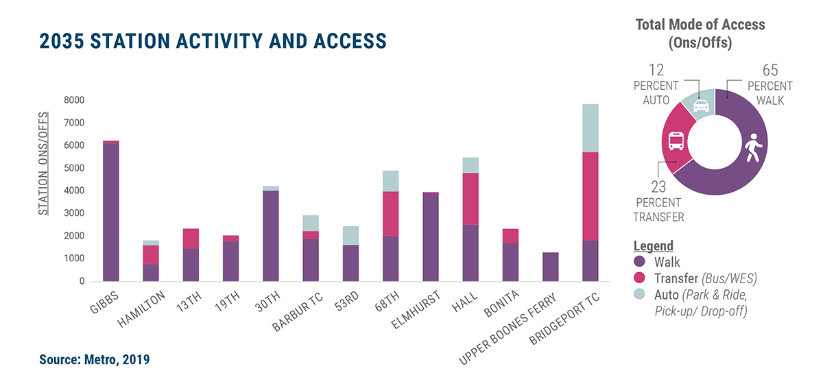
Regional modeling estimates that there will be 37,500 weekday trips on the Southwest Corridor Light Rail by 2035. Projected ridership and how people get to the stations affects how each station is designed. Below is information on how the project accounts for different ways of getting to the stations.


ridership data chart

Walking and Biking

Walking represents a sizable portion of how people are expected to access stations. To facilitate safe and comfortable walking connections, the project will contribute to a more fully connected, safe street network, with design treatments such as new mid-block crossings and sidewalks.

While biking is not accounted for in the regional ridership model, providing bike facilities is an important part of the project. Additionally, stations will accommodate secure locations to store and park bicycles with more space dedicated at stations demonstrating greater biking demand. The number of bike parking spaces at each station will be determined later in the design process.

Review biking and walking improvements on the Bike and Walk Improvements page.
Bike and walkshed map

Connecting community assets and neighborhoods

Transit and Transfers

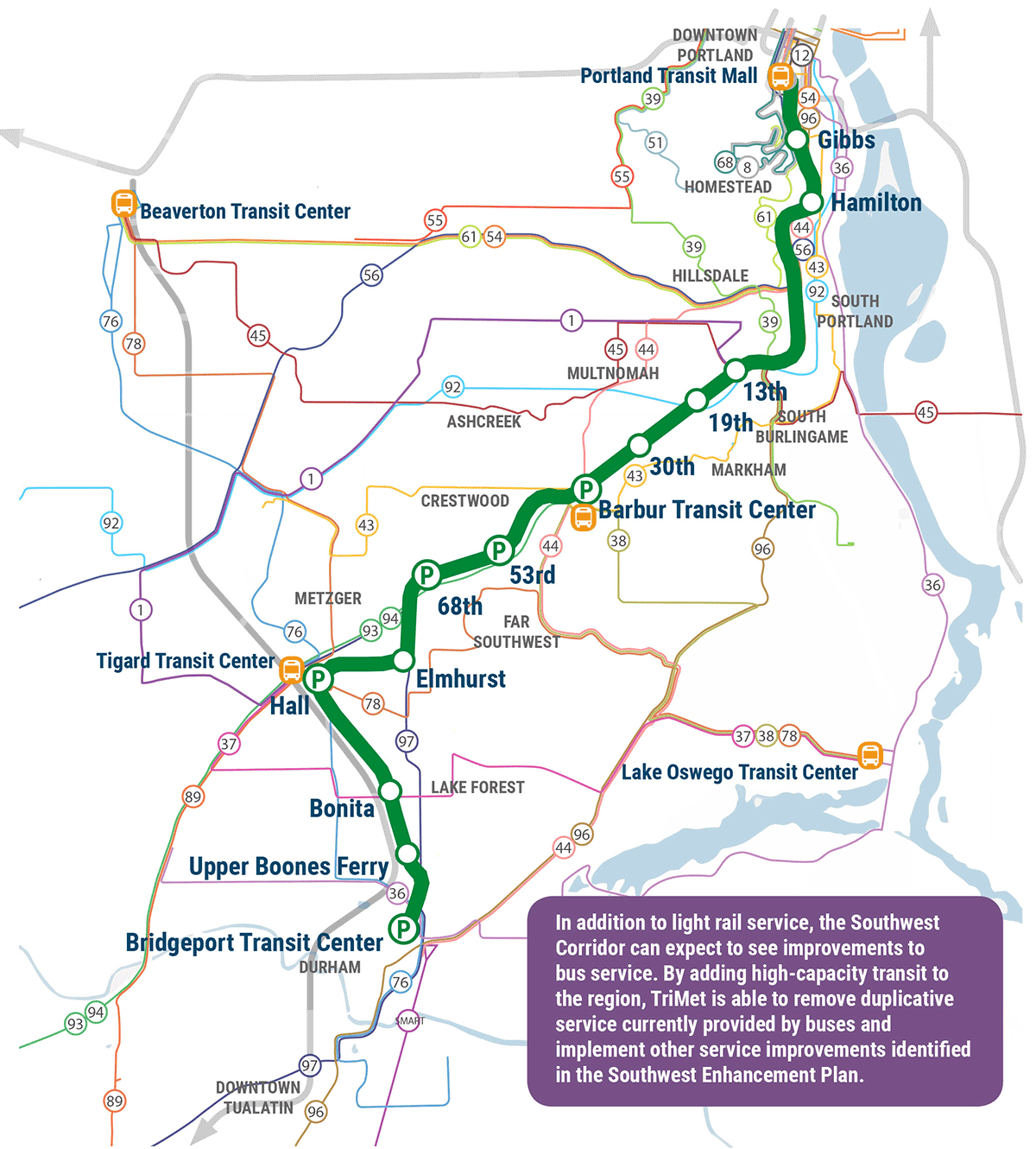
With the addition of Southwest Corridor Light Rail service, TriMet will make changes in the bus network to maximize ridership, create new connections and minimize duplication. For purposes of ridership modeling, planners have made assumptions about potential bus service changes, based largely on TriMet’s Southwest Service Enhancement Plan (SW SEP). About a year prior to beginning Southwest Corridor Light Rail service, TriMet will engage riders in a public process to revisit these assumptions and confirm a bus service plan that serves future needs while minimizing service duplication.

Potential bus network map

Potential bus network

환승 주차

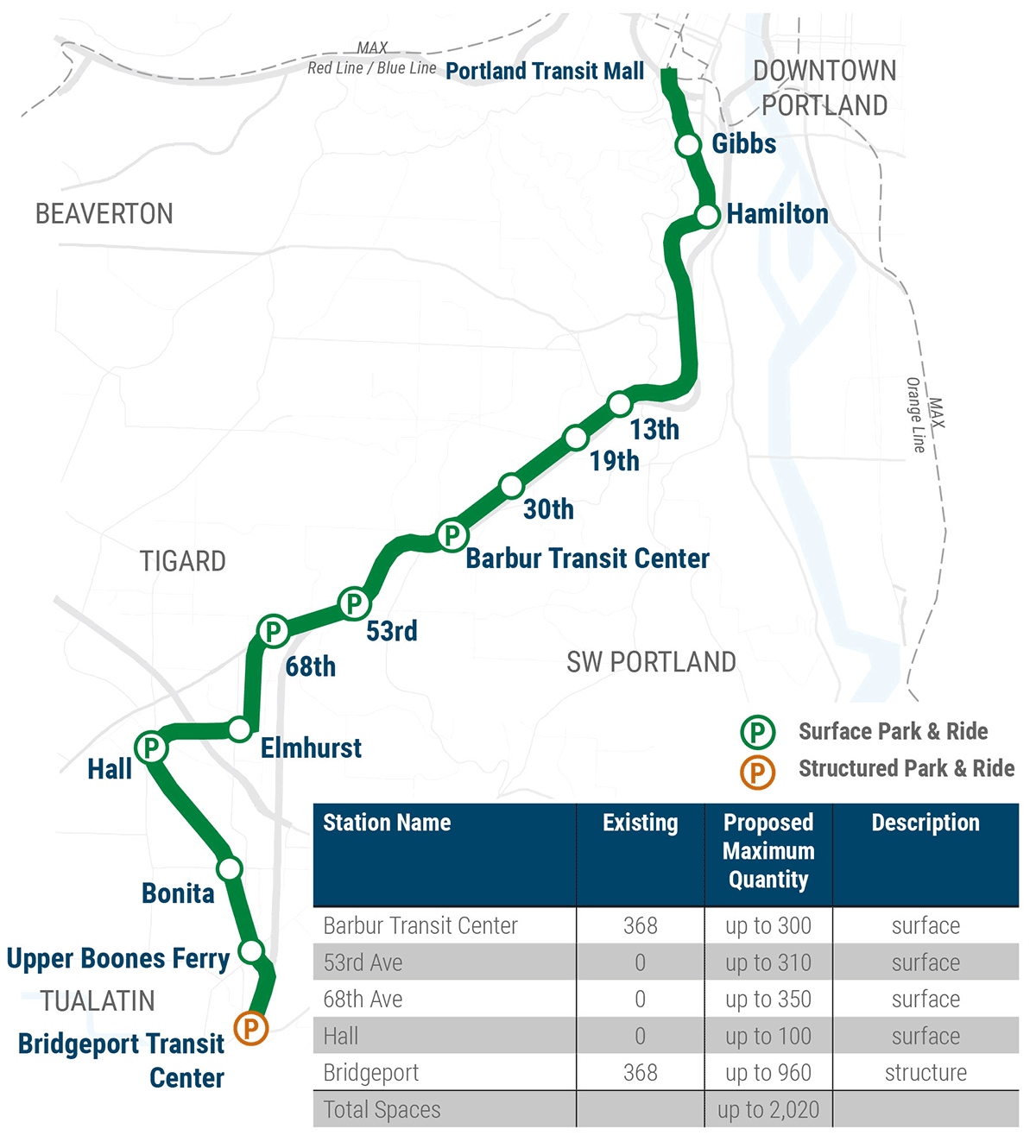
Park & Ride facilities serve riders traveling from farther distances or from locations without convenient transit service to access the light rail system. Community engagement in Spring 2019 helped define the currently proposed quantity, locations, and type of Park & Rides. All proposed Park & Ride quantities are subject to further traffic studies and could be reduced in future design refinements.

Proposed Park & Ride locations map

Proposed Park & Ride locations


의견 또는 궁금한 점이 있으십니까?

자세한 내용은 503-962-2150으로 전화하거나 이메일 을 보내십시오.


이메일을 등록하고 최신 정보를 받으십시오


프로젝트 파트너

TriMet북 지하 오레곤 교통국(ODOT) Washington Couty실 City of Durham City of Portland City of Tigard City of Tualatin